-
StatusCompleted
-
Status date2022-01-19
-
Activity Code5A.037
The Ge.Lo.Sy. Project focuses on the definition of a low-cost on-board geolocation technique. It must provide a preliminary design of the solution which is verified and validated at the laboratory level through the implementation of a proof-of-concept breadboard.
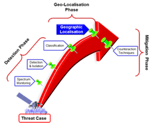
The figure shows the process of detection of radio frequency interference (RFI) which highlights the critical phase of defining the arrival direction to geo-locate the source or interfering sources present both in the coverage area of the satellite antenna and outside of it.
The proposed solution must be easily implemented on board both from the antenna side and from the transponder side. It must be able to act on a single satellite without having to use complex mechanisms on board. This gives the possibility to be integrated into the already defined SATCOM payload design, with reduced impacts on implementation costs.
The interest of SATCOM commercial operators in hosting an adequate anti-interference and anti-jamming (AI / AJ) subsystem on their payloads is growing. This interest is stimulating satellite space agencies (National and European) and satellite manufacturers to focus their attention also on effective AI / AJ solutions for the commercial market. Due to the implementation and integration costs of an adequate AI / AJ technical solution in a commercial context where the requirements in terms of protected bandwidth and performance are high, operators are focusing their attention on the techniques based on the direction of arrival (DoA). This choice allows to define and propose a more effective and accessible technology in terms of implementation feasibility and costs that can be customized on a wide range of satellites.
The proposed solution presents the following advantages:
-
ability to detect the direction of arrival of the interfering signal using a single satellite
-
simple design in terms of dedicated on-board equipment
-
easy integration into existing payload design
-
low implementation costs
-
cost-effectiveness for the commercial satellite operator that does not need the involvement of other specialized entities.
The main feature of the proposed solution is the capability of a single satellite to define the direction of arrival of interfering signal(s) without the support of other satellites.
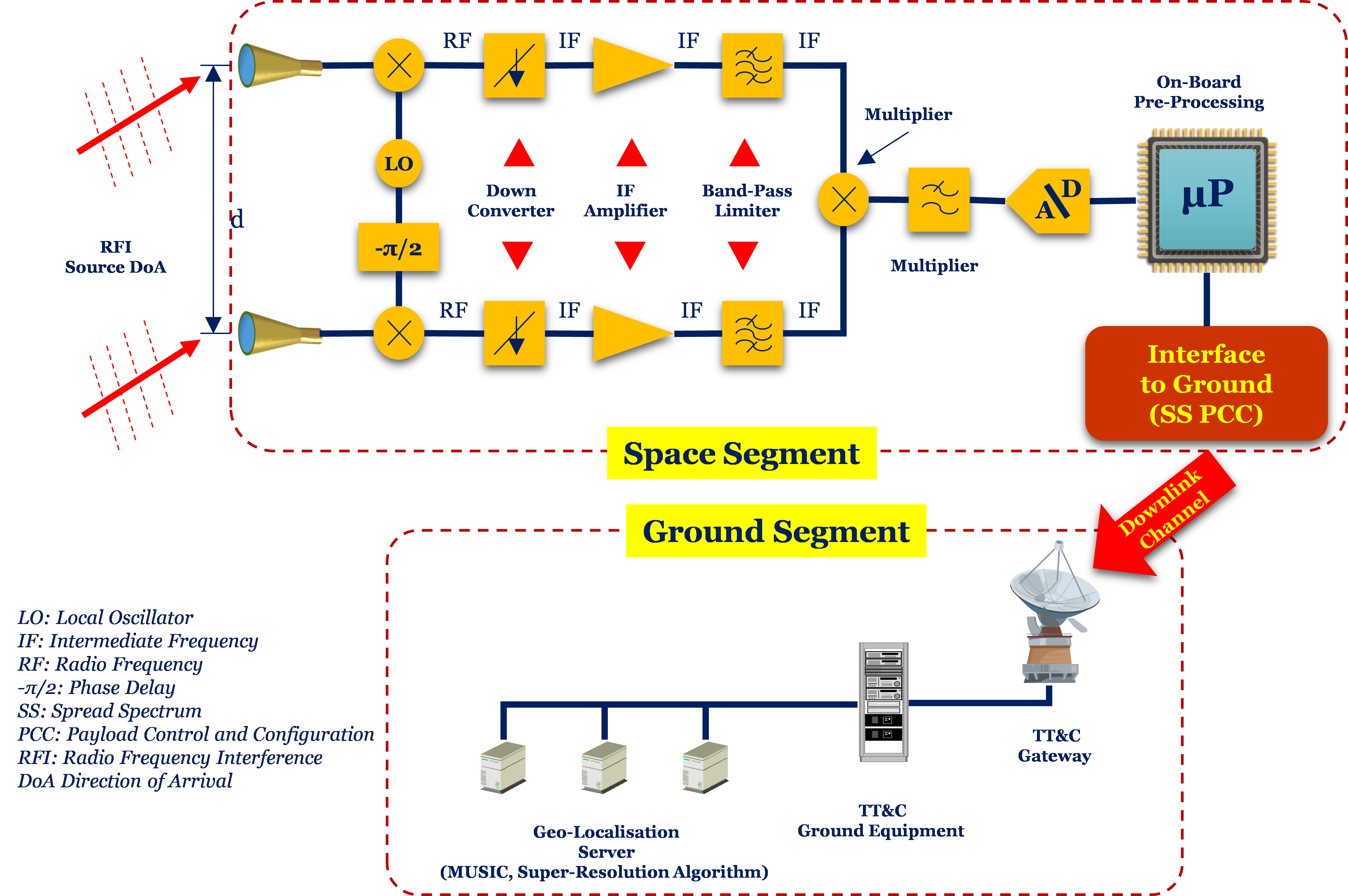
The components of the proposed solution are a set of receiving sensors installed on the antenna top floor, connected to a dedicated transponder in charge to digitalise the signals coming from the sensors and pre-processing them on-board. Pre-processed data are then forwarded to the ground station for the final definition of the geographic position of the interfering source(s).
The architecture of the technical solution defined in the study is described in the following figure:
The project is structured in five main phases: a. Identification of the RFI Scenarios and Reference Mission; b. Definition of RFI Geo-location techniques and algorithms; c. Detailed design of the selected RFI Geo-Location System; d. Design of RFI Geo-location System Breadboard; e. Breadboard Manufacturing testing and evaluation. Main Reviews are the Baseline Design Review (BDR), the Preliminary Design Review (PDR), the Test Review Board (TRB) and the Final Review (FR).
The activity has been concluded with the Final Review held on November 2021.
The main results consists in the implementation of the Proof-of-Concept (PoC) used in indoor and outdoor laboratory environment, this last representing a scaled layout of the target solution implementation and utilisation scenario. The target solution has been defined as Radio Frequency Interferometric Satellite System (RaFISS).
The obtained results confirm the suitability of the proposed, chosen and tested solution for the definition of the interfering sources localisation at the ground from a single satellite.