
-
StatusCompleted
-
Status date2016-04-06
There are two main objectives of the project. The first one is to develop and experimentally validate propagation models and relevant input data for the statistical prediction of radio interference on ground terminals of satellite systems. The second one is to implement the models into a software tool.
As it is obvious that the main important effects that need to be considered are diffraction and the atmospheric refraction, these two effects and their corresponding models are addressed in more details utilizing dedicated measurements. For the other effects, available models and experimental data have been adopted.
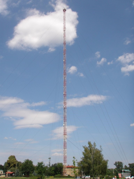
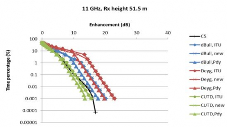
Figure 1: long-term measurements
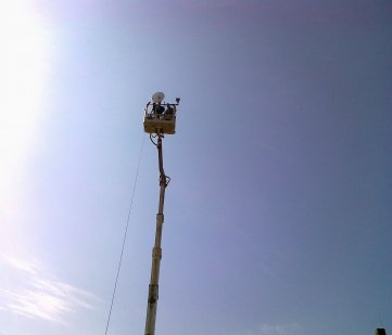
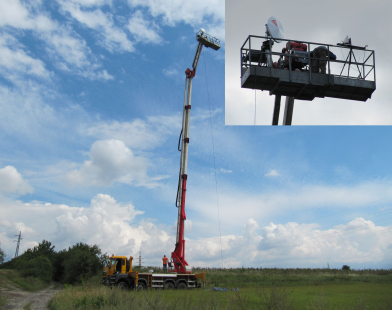
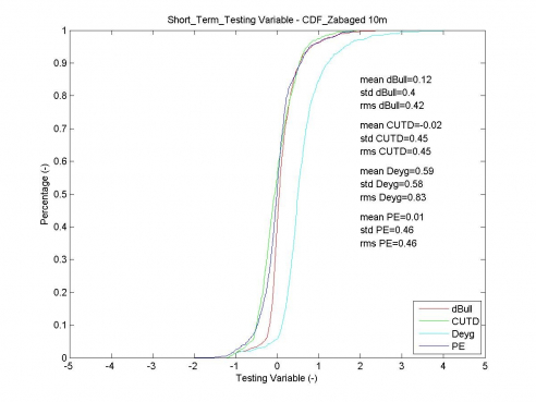
Figure 2: short-term measurements
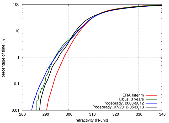
Figure 3: comparison between the new maps and local data
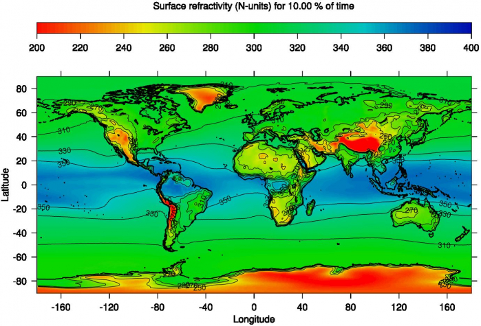
Figure 4: World map of surface refractivity quantile corresponding to 10% of time
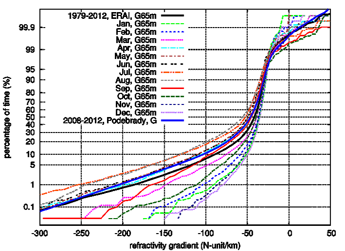
Figure 5: Monthly cumulative distributions of the vertical gradient in the lowest 65 m above surface; latitude 50.25, longitude 15.00
There are several key challenges related to each work package, namely providing global world map of refractivity based on the ERA‑Interim database (WP2), developing a new propagation model for diffraction (WP3), carrying out the short-term (WP4) and long-term (WP5) experiments, testing of the selected propagation models (WP6) and implementation of the SW tool (WP7).
In frame of CCN, the ERA-Interim datasets were processed so that monthly and whole year radiometeorological maps with 0.75° spatial resolution were produced (WP10), the current ITU-R 452-14 clutter loss model was compared with a UTD approach (WP11) and the SW tool was updated accordingly (WP12).
The expected main benefit of the project is that it provides tools that enable to thoroughly and accurately assess the spatial and temporal distribution of radio interference level and analyze the interference level for satellite communication systems caused by fixed terrestrial services that use the same frequency bands. This is achieved by deriving high-resolution radiometeorological maps and adopting/modifying the up-to-date propagation models and developing new ones using the experimental data obtained within short-term and long-term experiments.
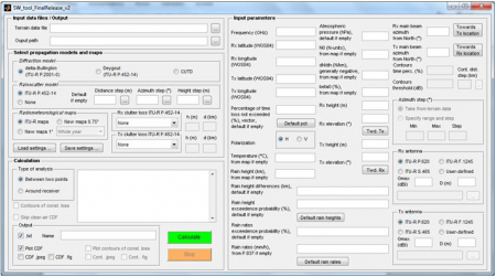
Within the project, the corresponding software tool for interference analysis was produced using the MATLAB environment providing a modular user-friendly structure with GUI. Each propagation model is implemented as a Matlab function with clearly defined inputs and outputs. These propagation models are called by the Core using the user-defined set of parameters. The desired outputs are generated to clearly given text or graphical files. Further, to extract a path profile from a worldwide terrain database, a separate external module is provided. Within the project, a high-resolution global radiometeorological map has been developed based on the ERA‑Interim datasets which is utilized by the software tool. A separate module with GUI serves as a main user interface for interference studies to generate all input files for the Core, to call the Core, and to present the outputs based on interactions with the user.
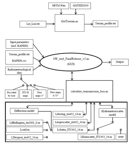
System architecture
The SW tool developed within the project follows the structure outlined above within its features and the architecture is shown in the diagram below.
The project duration has been 18 months and the corresponding work was split into nine work packages: state-of-the-art review (WP1), input data and maps processing (WP2), model development (WP3), short‑term measurements (WP4), long‑term measurements (WP5), interference models testing (WP6), SW tool implementation (WP7) and validation (WP8), management and reporting (WP9).
Within CCN, the project was extended by three months and three additional work packages: new radiometeorological maps with even finer resolution (WP10), clutter loss modeling (WP11) and SW tool upgrade (WP12) enabling to read the RAPIDS inputs as well.
The project including its CCN has been successfully finished in 2014 and all the required deliverables have been provided.