-
StatusCompleted
-
Status date2013-03-13
-
Activity Code6B.012
The project involves the analysis, design, implementation and validation of a fully passive and highly accurate ranging system for geostationary satellites. SES performs the requirements definition, system and software engineering. Fraunhofer Insitute of Technology is in charge of the development of the signal processing equipment.
The goals are to develop a system that:
- Provides highly accurate orbit predictions of geostationary satellites that allow dense collocation (up to 8 satellites) in one orbital box.
- Minimizes the impact of ranging operations on the satellite by avoiding the use of transponder invasive techniques. The system shall be payload signal independent.
- Responds to a global demand of geostationary satellite’s tracking and orbit data.
- Minimizes the cost of ranging operations by automating measurements.
The developed technology will allow SES to approach strategic partners, regulatory organizations and space agencies and offer them high quality orbit data on proprietary and/or third party satellites, or sell a turn-key PaCoRa system to operators. Deliverable: A first system deployed over Europe composed of 5 receiving antennas.
The system requirements aim to have a system able to measure passively on any kind of modulation scheme, and on bandwidths lower than 10MHz and/or Signal-to-noise ratio lower than 0.
The satellite movement will induce Doppler effect and time variations on the ground. The most complicated scenario occurs on highly inclined geostationary orbits. It will be addressed, and the necessary mechanisms and algorithms will have to be implemented in order to cope with these effects.
In order to produce orbit predictions that allow the collocation of up to 8 satellites in a single orbital slot, the project has to meet challenging requirements on the tracking system. The precision of the tracking data needs to be better than 30ns. Correlation precision and time synchronization between sites will be crucial for the performance of the system.
In order to have a fully passive system, an orbit determination model will be developed in order to compute orbits without a prior knowledge of the satellite maneuvers.
The expected benefits for SES and 3rd parties, compared to existing competitor systems, are:
- Orbit Determination
- Feed OD systems for regular ranging activities: While classical tone-ranging can only be performed on demand, PaCoRa ranging can be continuously active, providing up-to-date ranging data at any time.
- Cross-calibrate existing systems: For those satellite operators that want more than one system for redundancy purposes, PaCoRa offers an accurate basis for cross-calibration.
- Dense satellite-collocation: Up to 8 satellites in a single orbital slot.
- Share an orbital slot among two or more parties.
- Geolocation Through PaCoRa it is possible to obtain accurate ephemeris / orbit data of the primary and adjacent satellites. This increases the accuracy of the geographical location of the source of interference, and speeds up the geolocation process.
- Regulatory support Thanks to the passive, non-invasive nature of PaCoRa, any regulatory body can track a satellite transmitting a communication signal without the “approval” of the satellite’s owner.
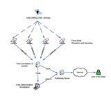
The system is composed of a tracking subsystem, an orbit determination subsystem and a back-end.
Tracking system:
Is formed of small size terminals (i.e.1.2m dish) that receive a regular satellite payload signal, sample the signal, timestamp it and transfer it via land lines to the central station. In order to achieve the best orbit calculations, 4 terminals are needed that have to be geographically spread within the satellite footprint. The Central station collects the sampled data and performs a time correlation that produces the TDOA. It is also in charge of automating and synchronizing the measurements of the distributed system.
Orbit Determination system:
The tracking data are fed into the orbit determination system that periodically triggers an orbit calculation. By knowing the precise location of the front-ends and using highly accurate models, the software computes the orbit.
Back-end:
The satellite tracking data (TDOA) and the orbit data (orbital elements) are stored in a safe database. The data which have to be published are pushed to the Publishing Server which allows data requests coming from the internet.
The Project execution started in June 2010, the deployment of the stations over the European continent took place during the fall of 2012. The Final Review took place in January 2013.
The Final Review was successful and the system was accepted. Since then, the system is being further consolidated by comparing its long-term performance to SES’ operational systems. In parallel, efforts are being put in commercialization and publicizing of the product.


