-
StatusCompleted
-
Status date2017-07-06
-
Activity Code1B.106
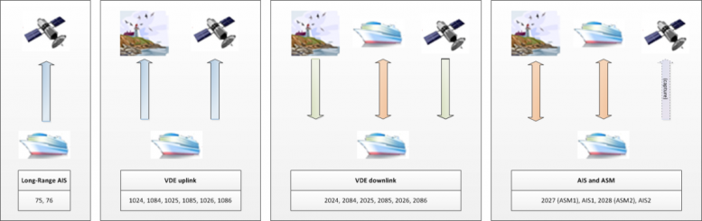
The activity provided a first feasibility assessment of maritime VHF Data Exchange via satellite (VDE-SAT) with the aim of
- Exploring user needs and required services potentially offered by VDES;
- Investigating applicable technical solutions and performing trade-off analyses;
- Identifying the benefits, constraints, and complementary aspects of VDE-SAT system with respect to a network that could be supported by alternative (existing) satellite space assets;
- Defining a roadmap for preparing the ARTES participating states industry in supporting the development of any such service / system.
- Identify and consolidate requirements and use cases addressing three potential groups of users: institutions, commercial and security/defence sectors.
- Quantify the VDE-SAT capabilities based on available resources, particularly the bandwidth and the maximum power flux density constraints for the data downlink.
- Ship equipment development and its integration with other services (such as AIS).
- Spectrum allocation for VDE-SAT services in World Radiocommunication Conference (WRC) 2019
- A common space/shore/ship communication system, with a long range VHF communication capability, in which the use of satellite or terrestrial links;
- An easier and cost effective equipment integration on-board the ship, in particular for the small size vessels (fishing), together with the mandatory or recommended AIS equipment;
- A cost-effective solution for low volume data broadcast, in particular aids to navigation, meteorological alerts, and more generally a cheap short messaging service.
VDE satellite component is a relevant solution for:
- small/medium ships not already equipped with high-rate SATCOM systems: fishing, sailing, and other small/medium ships;
- Reaching a large population of ships for broadcasting messages (e.g. ice-maps, security alerts) and to monitor fleet status (law enforcement, security, etc. );
- areas where coastal equipment is complex and/or insufficient.
The keywords for this technical solution:
- Multi-user: with adapted level of services, performance, security, operations
- Inter-operable: with AIS 1&2, AIS 3&4, VDE-TER, other VDE-SAT providers
- Real-time focused: with capability to react to most time-demanding applications, with strong links between uplink and downlink
- Flexible: with adaptive data coding, channeling, multi-access, single-access performance, multi-access performance
- Evolutionary: with unloadable software, taking into account future fleet evolutions
- Sustainable Investment: the demonstration, deployment, operation and services strategies shall allow a relevant investment.
The proposed solution is based on a constellation of Small satellites (between 12U-nano and small-micro) on a low orbit around 600 Km with a lifetime of at least 4 years and based on 6 satellite launch configuration.
The constellation solution for each use case includes a total of 6 up to 24 satellites.
Concerning the payload, the solution is based on a Yagi antenna for the uplink and on-board processing for the uplink and the downlink using a multi core processor. Based on the performance required by the use case and cost limitation, the satellite solution is half-duplex or full duplex.
For ground segment, the proposed configuration uses classical S-Band solutions for polar and equatorial control stations, and ad-hoc station in areas of interest requiring reduced timeliness (military and security domain)
The activity was divided into 3 major tasks:
- User needs collection, ending with the creation of an URD (User Requirement Document)
- System Concept design and trade-offs:
- Technical solution assessment, for payload, satellite, constellation, ground segment and shipborne devices;
- System simulations, taking into account the points mentioned above, the different modulations, to assess in particular the system capacity and performance;
- Business analysis, identifying the cost and revenues for different scenarios based on a SWOT matrix (comparison with ground systems and with other satellite systems), depending on the sizing of the space system and of expected users.
- Conclusion and roadmap, including the identification of the preferred solution to deploy a system with sufficient early revenues and acceptable level of risks to start generating revenues, used to progressively improve the system until full achievement of all user needs.
The study has been completed.