![]()
Advanced Satellite-AIS payloads launched aboard Norwegian satellites last year has boosted the number of ships tracked by up to 70% and ship positions received by factor of three.
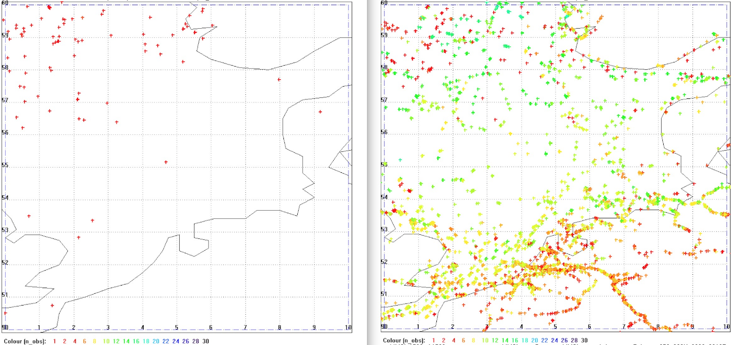
Statsat is the company operating the Norwegian satellites. Ivar Spydevold, its CEO, said: “By now we have been operating the improved AIS-receivers for four months with promising results. Combined, the number of messages from the NAIS-receivers on NorSat-1 and -2 typically reach 2.5 million per day. This is nearly three times more than the older version on AISSat-1 and 2 that achieved about 900,000 per day (combined).”
Jon Harr, programme manager for the satellite projects at the Norwegian Space Centre adds: “Detecting 60 - 70 % more ships per day is a significant improvement of the service.”
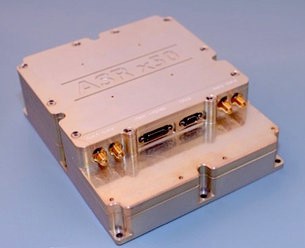
From a Low Earth Orbit of 600 km, the Novel Automatic Identification System (NAIS) receivers will acquire signals transmitted by Automatic Identification System (AIS), a maritime industry standard that is required on many vessels including cargo ships (over 300 gross tonnes), oil and gas tankers, fishing vessels (over 45m in length), and passenger ships.
Carsten Tobehn, ESA’s SAT-AIS programme manager said: ” The NAIS receiver was developed using the latest commercial off-the-shelf components. The gain of a more complex hardware and therefore also more complex software processing enables significant improvements in the NAIS message detection performance.”
The AIS system was primarily designed to prevent collisions between ships by monitoring and coordinating the messages between vessels. The Norwegian Coastal Administration is using the data to manage the national coast and waters related to safety, emergency and transport planning.
Using satellites increases the visibility range of these messages from around 74km (at sea surface) to 2500km (at low Earth orbit), meaning many more ships can be seen at any one time. In areas with heavy maritime traffic the number of AIS messages sent by ships can be so high that it jams the satellite’s AIS-receiver. The solution is a new type of AIS message (called type 27) which is more robust for reception by satellites with less interference from other messages.
Ivar Spydevold said: “Message type 27 allows our satellites to spot 20% more ships on a global scale. In critical areas, like the North Sea or the Mediterranean, the increase in the number of ships seen is substantially higher, since other message types are lost due to message overlapping.”
The NorSat-1 and NorSat-2 micro-satellites (hosting the NAIS payloads) are owned by the Norwegian Space Centre and will be operated by Statsat. Supported by ESA through the SAT-AIS element of ESA’s Advanced Research in Telecommunications Systems Programme, the receivers were developed by Kongsberg Seatex of Norway.