
-
StatusOngoing
-
Status date2014-11-24
Geolocation of interference signals by using just one satellite.
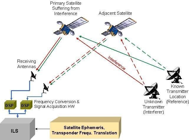
The main drawback of current geolocation systems is the necessity of having at least 2 satellites which are close enough to each other which is shown in the following figure.
The project shall implement functionality to localize the source of an interferer by using just one satellite.
The key issue of a geolocation in general is to reach an accuracy which helps the operator in the identification of the owner of an interferer. As it is very difficult to estimate the reachable accuracy of such system, we have done a basic investigation in the previous research project, which proofed that with the chosen solution an acceptable accuracy can be reached.
A one satellite geolocation solution will significantly increase the number of interference events which can be successful resolved.
Product will be much cheaper than a traditional geolocation system and therefore also attractive for small and medium satellite operators.
- The system shall provide a mechanism to localize the transmit station of an interference signal by using measurements from just one satellite.
- The system shall have an accuracy good enough to identify the transmit station of the interference signal on a map.
- The measurements to localize the transmit station of an interference signal shall be performed in a reasonable timeframe starting from the system setup until the localization report is available.
- The Operator shall have the possibility to generate a report containing the localization result including a screenshot of the map showing the calculated localization area.
- It shall be possible to apply the ONE-SAT-ILS functionality on all interference signals identified by the SIECAMS carrier monitoring system.
- The Operator shall have the possibility to start the ONE-SAT-ILS functionality directly on actual measurements from the SIECAMS carrier monitoring system.
- It shall be possible to just store the acquired data on the computer for later post processing like signal analysis or geolocation.
The project will be done in 2 phases. The aim of Phase1 is to refine and consolidate the requirements and provide a consistent design and architecture for the further development. Phase2 consists of the main development and validation tasks towards a product ready for sell.
The project is in its final stage.
Official sales launch was done at the CommunicAsia 2014 in Singapore. Official product name: SIECAMS® ILS ONE
Ready for sell: 12/2014